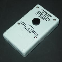
SRVY-XM4-BARO-2I Barometric Altitude GPS Data Logger

- Store up to 288,200 track log points
- Store either GPS or Barometric altitude
- Save position, time, date, altitude and event information
- EVENT button on front panel
- Nonvolatile Memory preserves data if power is removed
- Memory saving 'Automatic Save' function
- Long Battery Life
- Lightweight
- Click here for full specifications
Features:
| Model: | Data Stored: | Track Point Capacity: | Altitude (in metres): | ||||
|---|---|---|---|---|---|---|---|
| Position | Date | Time | GPS Altitude | Barometric Altitude | |||
SRVY-XM4-BARO-2I |
288,200 | 19999 | |||||
| 288,200 | 19999.9 | ||||||
| Position Resolution: | 20 centimetres | ||||||
| Event Sources: | 3 (1 Internal, 2 External) | ||||||
| Download Speed: | 115200 bps | ||||||
Why Use Barometric Altitude?
Barometric Altitude is becoming popular with many GPS users because it generally provides a smoother and more stable result than GPS altitude. This is valuable when GPS signals are masked by objects such as mountains, trees or buildings. For example, in 'urban jungles', multipath effects caused by large buildings can degrade GPS altitude accuracy.
Compatibility with GPS Receivers
This Datalogger is designed for, but not limited to, Garmin GPS receivers with a built-in barometric altimeter. Two suitable models are GPSMAP62S and GPSMAP78S. The GPSMAP78S is our recommended, lower cost option. For other GPS receivers, this Datalogger can record GPS altitude.
Why a special Datalogger model for Barometric Altitude?
Garmin GPS receivers send Barometric and GPS altitude in different NMEA sentences. GPS altitude is sent in the $GPGGA sentence. Barometric altitude is sent in the $PGRMZ sentence.
Can I choose to store GPS altitude if I want to?
This Datalogger can store either GPS or Barometric altitude. The type of altitude stored (GPS or Barometric) can be selected anytime, in the field, by setting a switch. This allows use with GPS receivers that do not have a barometric altimeter.
What data is saved?
This Datalogger saves position, time, date, altitude and event information.
Can Waypoints be saved?
There is an Event button on the Datalogger which will generate a waypoint marker when pressed. Also, two External Event inputs are provided, each is separately identified in the output data file. This makes a total of three separately identifiable Event (or Waypoint) sources.
Example Altitude Profiles
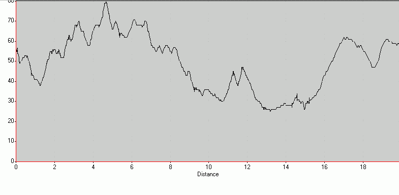
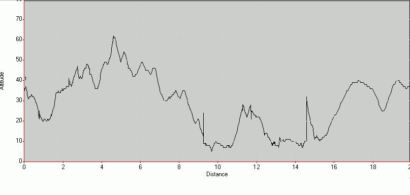
Both of the profiles below were taken simultaneously, using two Dataloggers. One Datalogger was set to record barometric altitude, the other was set to record GPS altitude. We used a GPSMap76S with software 2.01, and an external antenna. The sudden spikes in the GPS Altitude plot were likely caused by multipath or satellite masking. We hope to provide a more comprehensive set of examples soon.
Barometric Altitude Profile:

GPS Altitude Profile:

Package Contents:
- Data Logger unit complete with Event button
- Download Cable: Logger to PC
- GPS/Power Cable: Logger to 4 wires. (Versatile do-it-yourself hardwire to most GPS units.)
- Download software (PC Win95/98/NT4 compatible)
- Instruction manual
- 9V Duracell® alkaline battery included
- FREE delivery within Australia. Outside Australia please email us for courier costs!